- Introduction
- Hotokegaura (Aomori)
- Shirakami Sanchi (Aomori & Akita)
- Ryusendo Cave (Iwate)
- Sumatakyo Gorge & Yume no Tsuribashi (Shizuoka)
- Onyu Pass (Shiga)
- Cape Kamui, Shakotan Peninsula (Hokkaido)
- Kaminoko Pond (Hokkaido)
- Yakushima Island (Kagoshima)
- Oboke Gorge (Tokushima Prefecture)
- Ogasawara Islands (Tokyo)
- Conclusion — Beyond Convenience Lies Connection
Introduction
These are Japan’s hidden gems —places where modern life has slowed down enough
for nature, tradition, and time itself to breathe.
Some journeys in Japan can’t be rushed.
They don’t begin at a train platform or end at a souvenir shop.
They start when the roads narrow, the buses stop running, and the map begins to look almost empty.
In this guide, we’ll travel from the northern cliffs of Aomori to the faraway islands of Tokyo’s Pacific frontier.
Each destination may test your patience to reach, but every step rewards you with the kind of quiet beauty that only exists beyond convenience.
Hotokegaura (Aomori)
-1.jpg)
Hotokegaura is a dramatic 2 km stretch of coastline on the Shimokita Peninsula in Aomori.
Pale green and white tuff cliffs rise straight from the sea, carved by waves and wind into shapes that resemble Buddhist statues and temple halls — hence the name “Buddhas’ Shore.”
Sacred Coast of Stone Giants
On the remote west coast of Aomori’s Shimokita Peninsula stretches Hotokegaura, a two-kilometer shoreline lined with pale green tuff cliffs shaped by wind and waves.
Locals call it the Buddhas’ Shore, because the rocks resemble rows of divine figures — “Great Buddha Rock,” “500 Arhats,” and “Paradise Cliff.”
The scene feels otherworldly, like walking inside a natural cathedral carved by the sea.
-3-1024x576.jpg)
-7-1024x575.jpg)
Highlights
- Rows of towering rock formations with names like “Great Buddha Rock” and “Five Hundred Arhats.”
- Completely different perspectives from land (via walking trail) and sea (via sightseeing boat).
- When the weather is calm, the green-blue water and white cliffs look unreal in photos.
Getting There
- Nearest town: Sai Village, Aomori Prefecture
- By public transport:
- JR Shimokita Station → bus to Sai Port (about 2 hr 20 min)
- From Sai Port → sightseeing boat to Hotokegaura (around 40 min)
- By car:
- From Sai center to Hotokegaura parking area: about 50 min
- From parking → coastal viewpoint via walking trail: about 20 min one way
-4-1024x455.jpg)
Useful Tips
- The walking trail includes slopes and steps; wear walking shoes, not sandals.
- Boat + walking combination makes the visit much richer: for example, go by boat and return via the trail.
- Facilities are limited. Bring water and snacks with you.
Shirakami Sanchi (Aomori & Akita)
-7.jpg)
Shirakami Sanchi is a UNESCO World Heritage Site spanning the border of Aomori and Akita.
It preserves one of the world’s largest remaining primeval beech forests, where human impact has stayed minimal for thousands of years.
The Primeval Beech Forest of Northern Japan
A UNESCO World Heritage Site, Shirakami Sanchi preserves one of the world’s largest virgin beech forests.
For millennia, these trees have shielded rare birds, bears, and clear mountain streams.
One of the easiest ways to experience the forest is the Juniko Lakes area on the Aomori side.
Here, the cobalt-blue Aoike (Blue Pond) seems to glow from within — its color changing with the sun’s angle, its water so clear that fallen logs appear suspended in air.
-5.jpg)
-12-1024x683.jpg)
Highlights
- Dense beech forests with soft light and birdsong, ideal for slow walking rather than hard climbing.
- The Juniko Lakes area, especially Aoike (Blue Pond), whose cobalt-blue water looks almost illuminated from below.
- Seasonal beauty: fresh green in spring, deep shade in summer, stunning foliage in autumn, and a stark, snowy quiet in winter (for experienced hikers).
-4.jpg)
-1.jpg)
-10-1024x683.jpg)
Getting There
(Juniko / Aoike area, easiest for first-time visitors)
- By train:
- Take JR Gono Line to Juniko Station.
- From Juniko Station:
- Local bus or taxi to the Juniko Lakes parking area (about 15 min).
- Walking:
- From parking to Aoike: about 10–15 min on a well-marked trail.
- Several short loop trails connect other ponds and forest paths (1–2 hours total).
-15.jpg)
-8-1024x683.jpg)
Useful Tips
- This is a great “first wild place” in Japan for visitors who don’t want serious mountain hiking.
- Spring and autumn are best for color; summer offers cool shade compared to the cities.
- Trails can be muddy after rain; bring waterproof shoes if possible.
Ryusendo Cave (Iwate)
-4-1024x453.jpg)
Ryusendo Cave in Iwaizumi, Iwate Prefecture, is one of Japan’s three great limestone caves.
Over 4 km have been explored; about 700 m are open to visitors along a maintained route.
A Blue Underground Cathedral
In the mountains of Iwaizumi lies Ryusendo, one of Japan’s three great limestone caves.
Over 4,000 meters have been explored, but only 700 meters are open to visitors.
The highlight is the Third Underground Lake, plunging nearly 100 meters deep.
Its crystalline water glows a surreal “Dragon Blue” under the cave lights, making the whole cavern look like a sunken temple.
-6.jpg)
-3.jpg)
Highlights
- Several underground lakes, including the Third Lake with a depth of nearly 100 m.
- The water is incredibly clear and glows a deep “Dragon Blue” under the cave lights.
- The neighboring Ryusendo Science Museum explains how the cave and stalactites formed.
Getting There
- Nearest city: Morioka, Iwate Prefecture
- By bus:
- From Morioka Station, take a highway bus to Ryusendo (about 2 hr 10 min).
- By car:
- Around 2 hours from central Morioka.
-5.jpg)
-1.avif)
Useful Tips
- Inside temperature is about 10 °C year-round — bring a jacket, even in August.
- There are many stairs and some steep sections; wear shoes with a good grip.
- Photography is allowed in many areas, but watch your step — it’s easy to focus on photos and forget the stairs.
Sumatakyo Gorge & Yume no Tsuribashi (Shizuoka)
-3.jpg)
Sumatakyo Gorge, in Shizuoka’s Kawane region, is a mountain valley carved by the Oi River.
Its star attraction is Yume no Tsuribashi (“Bridge of Dreams”), a narrow suspension bridge over an emerald-green reservoir.
The Bridge of Dreams Above Emerald Waters
Hidden deep in the mountains of Shizuoka’s Kawane region, Sumatakyo Gorge is famous for its Yume no Tsuribashi—the “Bridge of Dreams.”
This 90-meter-long suspension bridge sways gently over a turquoise reservoir, surrounded by untouched forest.
The experience is thrilling but serene, as you walk above a lake glowing with reflected light.
After crossing, rest your legs in Sumatakyo Onsen, known for its smooth “beauty waters.”
-1.avif)
-2-1024x683.jpg)
Highlights
- A 90 m-long swaying suspension bridge with a beautiful view down to blue-green water.
- A scenic hiking loop through forest, riverside, and bridge viewpoints (around 90 minutes).
- Sumatakyo Onsen in the nearby hot-spring town — perfect after the walk.
Getting There
By train & bus:
- Take the Oigawa Railway to Senzu Station.
- From Senzu, local bus to Sumatakyo Onsen (around 40 min).
On foot:
- From Sumatakyo Onsen bus stop to the trailhead: about 20 min walk.
- From the gate down to the bridge: about 8 min of stairs.
-1-1024x458.jpg)
Useful Tips
- During holidays and autumn foliage season, there can be long queues to cross the bridge; early morning is best.
- The loop trail includes steep stairs and can be slippery — avoid dress shoes or heels.
- Combine with a ride on the old-style steam locomotive of the Oigawa Railway for a nostalgic day trip.
Onyu Pass (Shiga)
-6.jpg)
Onyu Pass is a high mountain pass (around 820 m) on the border of Shiga and Fukui Prefectures.
It’s famous among Japanese photographers for its sea of clouds and sweeping ridge-line views.
Japan’s Road Above the Clouds
Bordering Shiga and Fukui Prefectures, Onyu Pass sits 820 m above sea level.
From late autumn to early winter, clouds gather in the valleys below, turning the ridge road into a path through a white ocean.
Photographers come for the sea of clouds at sunrise, while night travelers capture stars above a glowing mist.
ven in autumn.
-3.jpg)
-9.jpg)
Highlights
- From late autumn to early winter, valleys below the pass often fill with clouds at sunrise.
- On clear nights, you can photograph stars above a blanket of mist.
- The ridge road itself can feel like driving through the sky when the clouds are just below you.
Getting There
- By car only:
- From Kyoto City, drive about 2 hours via Route 367 (Saba Kaidō) toward Takashima and then up mountain roads to the pass.
- Public transport:
- There is effectively no convenient public transport to the pass — this destination requires self-driving.
-4-819x1024.jpg)
-11-819x1024.jpg)
-1.avif)
Useful Tips
- The road is narrow with sharp curves and limited guardrails; avoid night driving unless you are very confident.
- The mountain road is usually closed in winter due to snow; check road conditions in advance.
- For sea-of-cloud conditions, aim for a cold, clear morning after rain, and arrive before sunrise.
Cape Kamui, Shakotan Peninsula (Hokkaido)
-1.jpg)
Cape Kamui sits at the tip of the Shakotan Peninsula in Hokkaido and offers one of Japan’s most impressive coastal views.
A narrow trail along tall cliffs leads to a lighthouse surrounded by the famously bright “Shakotan Blue” sea.
The Edge of the Blue World
Jutting into the Sea of Japan, Cape Kamui offers some of Hokkaido’s most dramatic coastal scenery.
A narrow trail called Charenka’s Path winds along 80-meter cliffs to a lighthouse at the tip, with the sea below shimmering in “Shakotan Blue” — a color so deep it looks painted.
no shelter.
-2-1024x682.jpg)
-2-1-1024x680.jpg)
Highlights
- A 20-minute walk along Charenka’s Path with open views of cliffs and ocean.
- Clear days reveal multiple shades of blue, from turquoise near the cliffs to deep navy offshore.
- The cape has a spiritual history and was once off-limits to women, adding cultural interest to the scenery.
Getting There
- By car:
- About 2 hr 30 min from Sapporo, or 1 hr 30 min from Otaru.
- By bus:
- Seasonal buses may run from nearby towns, but service is limited; most visitors rent a car.
-4-1.jpg)
-6-1024x686.jpg)
Useful Tips
- There is almost no shade or shelter along the path; bring a hat, sunscreen, and water.
- Strong winds are common. If the path is closed due to safety concerns, obey all signs.
- Combine with fresh seafood (especially uni, sea urchin) in nearby Shakotan towns.
Kaminoko Pond (Hokkaido)
-6-1024x462.jpg)
Kaminoko Pond in Kiyosato, eastern Hokkaido, is a small pond with strikingly clear, blue-tinted water.
Its name means “Child of God Pond,” and local legend says its water comes from nearby Lake Mashu.
The Mysterious “Child of Lake Mashu”
In eastern Hokkaido’s Kiyosato Town, a small pond glows an impossible shade of blue.
Known as Kaminoko-ike — “Child of God Pond ”— it’s said to be fed by underground springs from Lake Mashu.
The constant 8 °C water is so clear that fallen trees rest visible on the bottom, perfectly preserved.
-1-1-1024x677.jpg)
-1.jpg)
Highlights
- Crystal-clear blue water with fallen trees resting visibly on the bottom.
- Constant temperature around 8 °C, which prevents the wood from decaying and adds to the eerie stillness.
- A short, easy forest walk around the pond — peaceful and quiet even compared to other nature spots.
Getting There
- By car:
- From central Kiyosato, drive along Route 1115 toward Nakashibetsu for about 25 km.
- Turn onto Hatoi Forest Road (unsealed) and continue about 2 km to the parking area.
- No convenient public transport reaches the pond directly; a rental car is highly recommended.
-4.jpg)
-10.jpg)
Useful Tips
- The forest road is narrow and can be rough; drive slowly and carefully.
- Mobile reception is weak or nonexistent; download maps beforehand.
- Visit on a sunny morning for the brightest blue; on cloudy days, the color is more subdued but still beautiful.
Yakushima Island (Kagoshima)
-2.jpg)
Yakushima is a lush, mountainous island south of Kagoshima, and a UNESCO World Heritage Site.
Within a compact area, it packs subtropical coastline, dense cedar forests, and high alpine ridges, making it feel like several worlds combined.
Where Rain Creates Eternal Green
A UNESCO World Heritage island south of Kyushu, Yakushima is a microcosm of Japan’s nature.
Its mountains reach nearly 2,000 m, rising from subtropical beaches to alpine ridges within just 30 km.
Moss-covered forests, giant cedar trees like the Jomon Sugi, and constant rainfall (“it rains 35 days a month,” locals joke) give the island its mystical atmosphere.
-1-1024x683.jpg)
-4-1024x682.jpg)
Highlights
- Ancient cedars such as Jomon Sugi, estimated to be thousands of years old.
- Shiratani Unsuikyo gorge, with moss-covered rocks and trees that inspired scenes from anime films.
- Frequent rain that turns the forest into a glowing green world — here, rain is part of the charm.
Getting There
- By ferry / high-speed boat:
- From Kagoshima Port to Yakushima: about 1 hr 45 min – 4 hr, depending on the vessel.
- By air:
- Flights from Kagoshima Airport to Yakushima Airport (around 35 min).
- On the island:
- Buses run around the coast, but a rental car gives much more freedom.
-3-1024x685.jpg)
-12.jpg)
Useful Tips
- For long hikes like Jomon Sugi or Mt. Miyanoura, hire a local guide and bring full hiking gear.
- Pack proper rainwear (jacket and pants), not just an umbrella — trails can be muddy and slippery.
- Plan at least 2–3 nights; the island is too rich for a simple day trip.
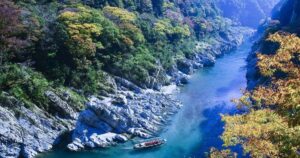
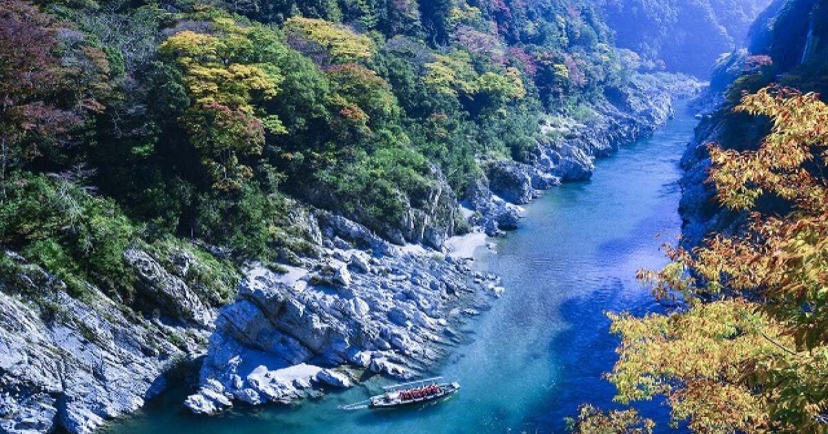
Oboke Gorge (Tokushima Prefecture)
-5.jpg)
Oboke Gorge (pronounced “Ōboke”) lies along the Yoshino River in Tokushima Prefecture, Shikoku.
The river has carved strange, folded rock formations over millions of years, creating a steep, narrow canyon.
Where River and Stone Collide
Carved by the Yoshino River over millions of years, Oboke Gorge (written 大歩危, read Ōboke) is a canyon of sculpted metamorphic rock.
Boat tours glide through emerald waters between cliffs that twist like folded paper.
Nearby, the smaller Koboke Gorge and rafting courses attract adventure seekers, while hot-spring inns offer slow evenings overlooking the river.
-1-1024x683.jpg)
-11.jpg)
Highlights
- Sightseeing boat cruises through emerald-green water between towering rock walls.
- The nearby Koboke Gorge and rafting courses for more adventurous visitors.
- Easy access compared to some other “hidden” spots, yet still very much a wild river valley.
Getting There
- By train:
- JR Oboke Station on the Dosan Line.
- From the station:
- About 20 minutes on foot or a short taxi ride to the pleasure-boat pier.
- By car:
- Accessible from Tokushima or Kochi via Route 32.
-12.jpg)
-3.jpg)
Useful Tips
Autumn foliage season is especially photogenic.
Boat cruises usually operate from around 9:00 to late afternoon; check the latest schedule in advance.
Combine Oboke with nearby Iya Valley (vine bridges, deep ravines) for a fuller “Shikoku mountain” itinerary.
Ogasawara Islands (Tokyo)
-1.jpg)
The Ogasawara Islands (also called the Bonin Islands) are a remote Pacific archipelago administratively part of Tokyo — but nearly 1,000 km south of the city.
There is no airport; the islands are reachable only by a single passenger ship, the Ogasawara-maru.
A 24-Hour Voyage to Japan’s Last Frontier
Nearly 1,000 km south of Tokyo, the Ogasawara Islands — including Chichijima and Hahajima — are accessible only by one ship, the Ogasawara-maru.
It sails once a week from Tokyo’s Takeshiba Pier, taking 24 hours each way.
There is no airport.
That remoteness protects an ecosystem found nowhere else on Earth — nicknamed the Galápagos of the East.
Swim with dolphins, spot humpback whales, or hike through forests of endemic plants.
-9.jpg)
-1-1.jpg)
Highlights
- A 24-hour ocean voyage that feels like a small expedition before you even arrive.
- Exceptionally clear tropical waters with dolphins, sea turtles, and seasonal whales.
- High levels of endemism: plants, insects, and birds that evolved only here, earning the nickname “Galápagos of the East.”
Getting There
- By ship only:
- The Ogasawara-maru departs from Tokyo’s Takeshiba Pier to Chichijima (Father Island).
- One-way journey: about 24 hours.
- The ship typically stays three nights at Chichijima before returning, making the shortest trip 5–6 days.
- Between islands:
- The Hahajima-maru connects Chichijima and Hahajima in about 2 hours.
-2.jpg)
-8-1024x683.jpg)
Useful Tips
- Seas can be rough; bring seasickness medication and plan for possible delays.
- Accommodation on the islands is limited; book lodgings as soon as your ship ticket is confirmed.
- There are strict rules for wildlife watching and trekking — follow local guides’ instructions to help protect the fragile ecosystem.
Conclusion — Beyond Convenience Lies Connection
All ten of these places have something in common : they are not designed for quick, convenient tourism.
You might have to :
- Take a bus that runs only a few times a day
- Drive a narrow mountain road
- Hike longer than you’re used to
- Spend a full day on a ship, far from the mainland
But in return, you’ll find :
- Silence where you can hear wind and water instead of traffic
- Landscapes shaped more by time than by humans
- A feeling that you’ve stepped out of your normal life and into a different rhythm
Every destination on this list asks something from you : time, patience, or courage to leave the easy route behind.
But in return, they offer something modern travel rarely gives — silence, space, and a sense that the Earth is still alive beneath your feet.
These ten hidden gems are not quick photo stops ; they are journeys—each with its own rhythm, climate, and character.
Choose just one that speaks to you, and plan your trip around that place.
Let it set the pace of your journey.
Because in Japan, the further you travel from convenience, the closer you often come to something real.
The Japanese version of this article is here.↓↓↓